

You can find on this page the Seville neighborhood map to print and to download in PDF. The Seville districts map presents quarters, region, suburbs and surrounding area of Seville in Spain.
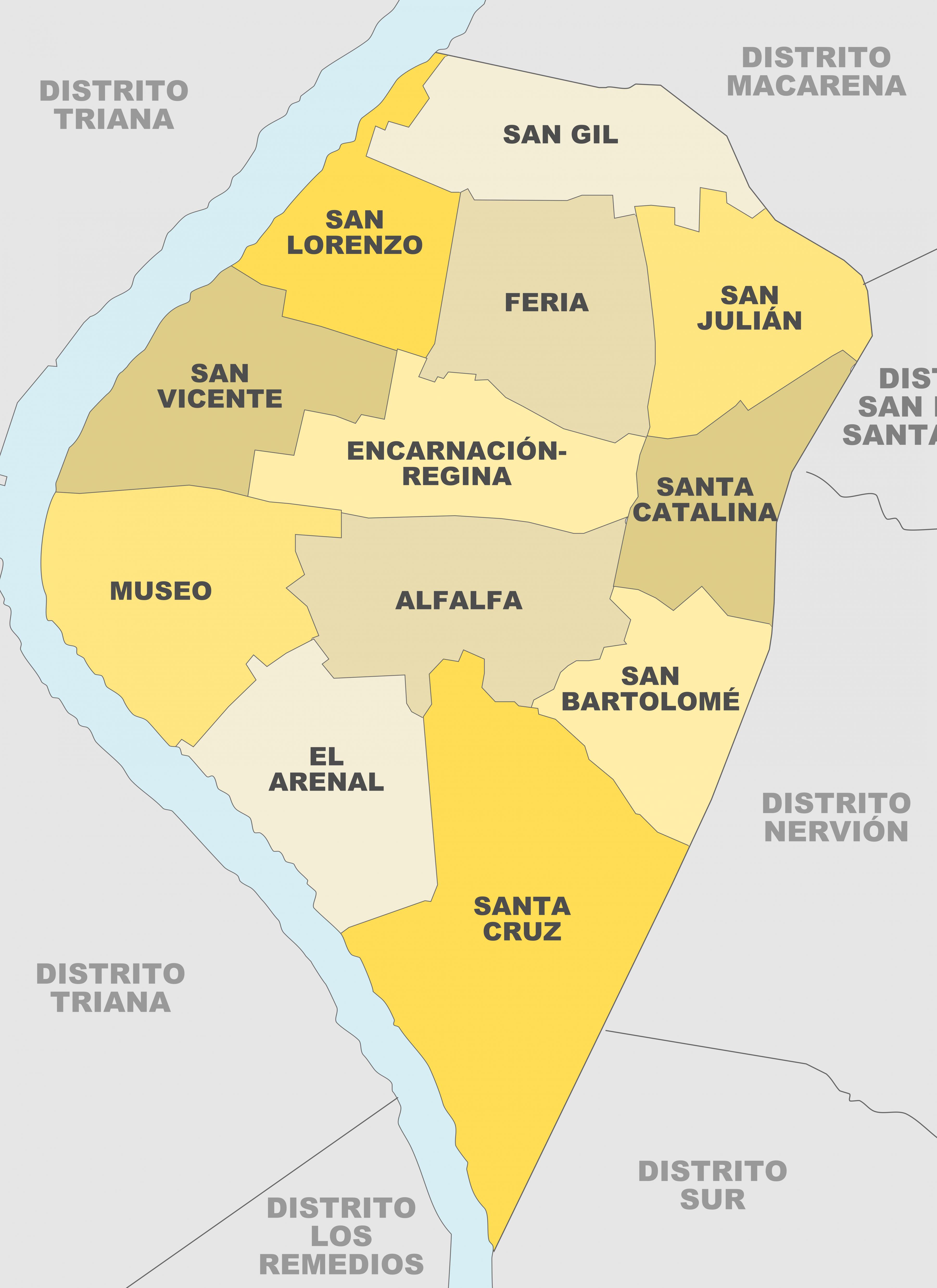
The Seville neighborhoods map shows region and suburbs of Seville areas. This neighborhood map of Seville will allow you to discover quarters and surrounding area of Seville in Spain. The Seville quarters map is downloadable in PDF, printable and free.
The economic activity of Seville cannot be detached from the geographical and urban context of the city; the capital of Andalusia is the centre of a growing metropolitan area. Aside from traditional neighborhoods such as Santa Cruz, Triana and others, those further away from the centre, such as Nervión, Sevilla Este, and El Porvenir have seen recent economic growth as its mentioned in Seville neighborhoods map.
The neighbourhood of Triana, situated on the west bank of the Guadalquivir River, played an important role in the history of the city and constitutes by itself a folk, monumental and cultural center. On the other hand, La Macarena neighbourhood is located on the northern side of the city center as youcan seein Seville neighborhoods map. It contains some important monuments and religious buildings, such as the Museum and Basilica of La Macarena or the Hospital de las Cinco Llagas.
The La Alfalfa neighbourhood houses many pubs and tapas bars (see Seville neighborhoods map). A more alternative atmosphere can be found in La Alameda, with a frenetic nightlife of entertainment that ranges from traditional flamenco to heavy metal. Another popular area is El Arenal. Most of the discothèques are found in Betis street in Triana and in La Cartuja.

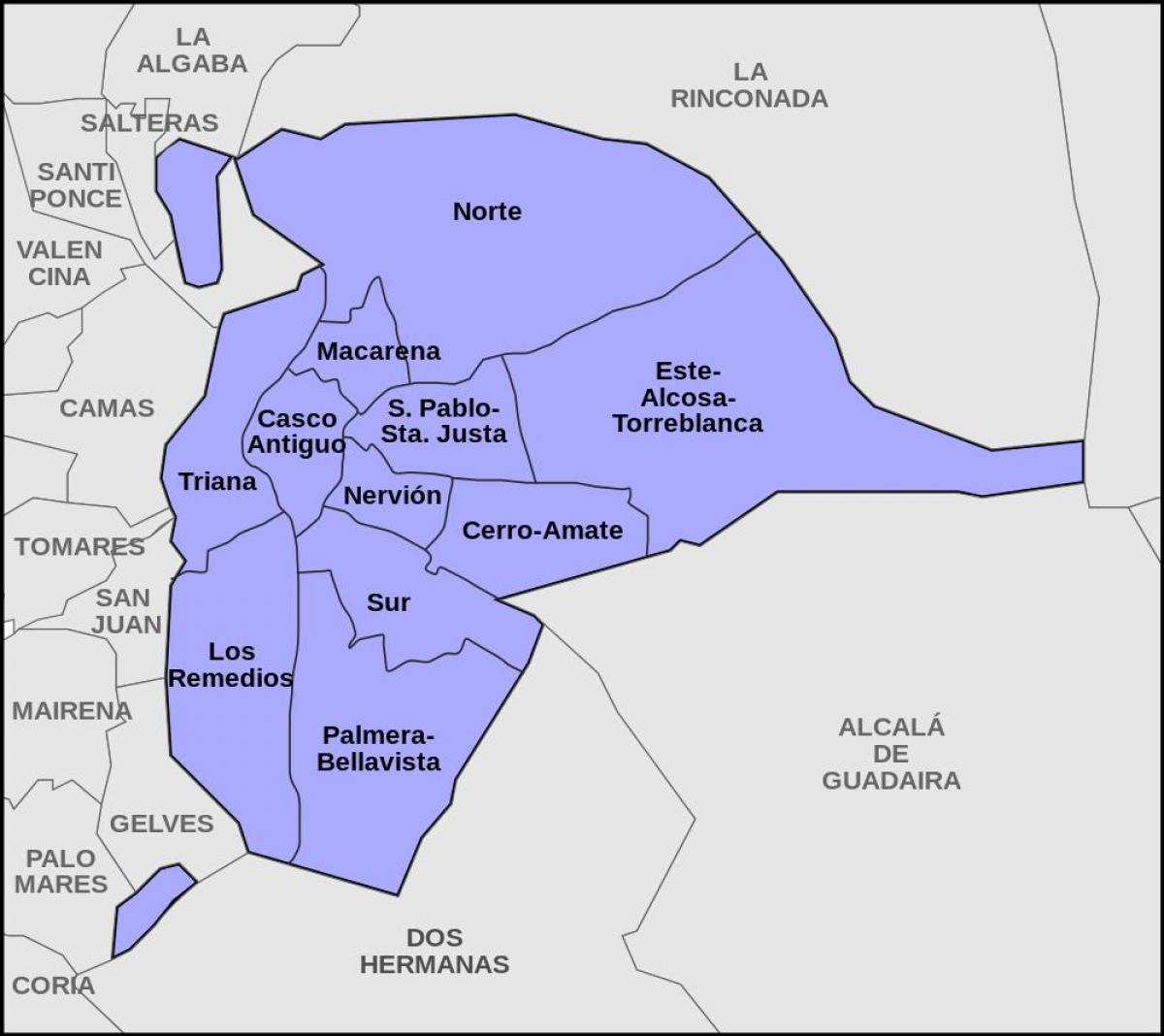
The Seville districts map shows all quarters and suburbs of Seville. This district map of Seville will allow you to discover areas and the region of Seville in Spain. The Seville districts map is downloadable in PDF, printable and free.
Seville has 11 districts as you can see in Seville districts map. Bellavista – La Palmera, is one of the southernmost districts of the city, bordering the municipality of Dos Hermanas. Casco Antiguo, This is where most of the tourist attraction sites of Seville are located, such as the historical monuments (the Cathedral, Giralda, Real Alcazar, Basilica de la Macarena, Archivo de Indias …). Cerro – Amate, The district is now one of the most populous areas in the city and it borders the municipality of Alcalá de Guadaira. Este – Alcosa – Torreblanca, This is the easternmost of the Seville districts and also the one with the largest population.
Los Remedios, This is one of the most exclusive areas of the city, especially in the neighbourhood that shares its name with the district. Macarena, to the north of the Old Town as its shown in Seville districts map (Casco Antiguo), the Macarena district comprises the old suburb of the city, known for its highly characteristic monuments. Nervión, the numerous metro and bus stops and the proximity of the Santa Justa station make Nervión one of the best located and connected districts of the city. Norte, the district includes the Alamillo Park, one of the largest green areas in Seville.
San Pablo-Santa Justa, this district combines a great social mix and a remarkable commercial offer with its proximity to the urban centre as its mentioned in Seville districts map. Sur, The Iberian-American Exhibition that hosted Seville in 1929 gave a boost to the urbanisation process in the Sur district in the neighbourhood of El Prado-Parque de María Luisa. Triana, is yet another excellent tourist attraction area. The district of Triana happens to be one of the most traditional points of the city, with the busy Plaza del Altozano as a great nerve centre and the island of La Cartuja as one of the must-visit destinations.